Liberty Freeway

| ||
|---|---|---|
| Liberty Freeway | ||

| ||
| Part of the America's Freeway System | ||
| Built/maintained By: | AMDOT | |
| Other name(s): | Interstate 1 | |
| Formed: | January 2006 | |
| Lenght: | 2,360m(236cells) + south extension (lentgh:unknown) | |
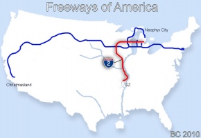
| South end: | World's GZ Territory | |
| Junctions: | ||
| North end: | Eastview Blvd, Neophyx | |

| ||
| This article is about the freeway network in the world of America | ||
The Liberty Freeway, or Interstate 1, is a national freeway road in the world America. It is the second freeway in America by lenght and the second oldest after the Alphaway Expressway in 2003 in Neophyx City. Being the busiest road in America, the Liberty Freeway serves as the main corridor between the GZ of America and the metropolitan area of Neophyx City.
History

First section January 2006
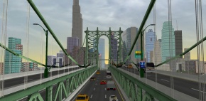
After the construction of the Hamilton bridge, now Liberty Bridge, Neophyx's 2nd bridge to be built in its early time, only a short portion of road was extended on the west shore's accidented ground and it remained a dead end without any formal plan for it for almost two years just like for its older twin, the Victoria Bridge. It is the announcement of the creation of movers that would come in the upcoming 4.1 version of Active Worlds that gave a little push to this dormant situation. Now that it was known that users would soon be visiting the area by cars, Nyxboy knew that a reform in the road network, until then only used by foot, would be very benefic for Neophyx City. Since the most practical way to reach the city until then was through teleportation, praticly no road access had been built between Neophyx and America's GZ.
After a short study of the area, Nyxboy decided to build, what he considered his first real freeway, from the Hamilton bridge all the way to reach America's, already existing, rural road network as an attempt to approach as close as possible the link from the city to the GZ area and the rest of the developed area of the world. The freeway has been named after the bridge and the tunnel to which it was linked to create the new Hamilton Expressway.
The Interstate 1 has been since the most important passage to be used by a majority of visitors coming to Neophyx City by movers.
Ferther Additions Summer 2006
But it is later, at the end of August 2006, that the tunnel would be included as a part of the Hamilton Freeway when it has been upgraded into a double tunnel with the freeway standards and extended on the other side to meet with Nelson Blvd on Neophyx's east shore for a better access and allow potential ferther extensions.
In july 2006 a pedestrian path has been added to the Hamilton bridge and in August 2006 the bridge also faced a major restructuration to be upgraded into a 2-level bridge doubling its capacity passing from 2 to 4 lanes for each directions. The upper level's 4 lanes has been fully linked since but those on the lower one were merging into 2 when exiting on the west side until the 2 spear lanes have been opened to a tunnel linking the new Expressway 101(now Interstate 201) on May 16th 2009.
Considered Modifications in 2009
Since the addition of the Neophyx Freeway to the surrounding network of Neophyx City, it has been once considered a possibility that the portion of the Liberty Freeway between the Transamerica and the 201 could be removed. The necessity of this portion being reconsidered since there were now 2 different ways to go to the city through a non developed area and that, with the new 201 it would have been possible to reach both bridges from the Transamerica. Although far from making an official decision on this dilemma, these considerations were enough to cause BC to orient their priorities elsewhere. This has caused the 3 level stack interchange between the Transamerica and the Liberty Freeway to remain uncompleted and the Liberty Freeway has never been modernized since like the other freeways of the network were.
NC9 Plan and the decision to keep the freeway (2010)

In 2010, BC and the Amworld Transport Department has decided that the freeway would be incorporated in the NC9's projects considering that the Interstate-1 makes a better main link to the city as it takes people directly to the city's main area without having to transfer, which would have become the case if the Transamerica I-1 had to become the main corridor to Neophyx for traffic coming from the GZ.
The freeway being, then, identified as an auxiliary Interstate(I-190) has been renumbered by the NC9's freeway renumbering plan to become the Interstate 2. The structure has also been progressively updated to meet the current higher road standards.
Renaming and extension towards South
Renaming
On August 10th 2010 the Hamilton Freeway and the Hamilton Bridge have been renamed to become the Liberty Freeway and the Liberty Bridge. The Hamilton Tunnel was not renamed though renaming of the tunnel is kept on hold in the NC9's projects until an official decision will be made.
Extensions to Ground Zero
In August 2010, studies for a southern extension to link the Interstate 2 to the Ground Zero began. The project was proposed to America on August 10th 2010 and has been aproved the day after on August 11th.
The groundbreaking happened on August 14th 2010 and the new portion has been completed by the end of the same month.
2012
In November of 2012, the section of the Liberty Freeway between its jonction with the Transamerica Freeway and West Neophyx has been rebuilt completly. The new section built in parrallel to the old one on its north was meant to replace the older infrastructures dating from 2006 by more modern ones. The traffic has been transferred on the new route upon opening on Nov 29th 2012. Rebuilt closer to the site of the American Race Tracks, the route has been relocated on purpose for better space management of the land in this region. The old structures were to be demolished by the end of 2012.


Controversy
The decision to mordernize the infrastructures in this area by replacing them by new ones has been criticized especially in regards of the AmWorld Transport's decision to demolish the Liberty Arched Stone Viaduct built in 2006.
2013
Since January 23rd of 2013, based on a second revision to the NC9 renumbering, the Liberty Freeway is identified as the Interstate 1.
Extension projects
In early 2013, the federal government of America met with AmWorld Transport to discuss the possibilities to extend the Liberty Freeway all the way to the southernmost regions of the world.
Gallery
-
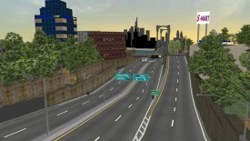
Southern portion of the Liberty Freeway.
-
Liberty Bridge, main link between Downtown Neophyx and mainland America.
-
View on Liberty Bridge in Neophyx City.
See also
| Freeways of America | |||||||||||
|
|
• |
|
|
• |
|
• |
|
• |
|
• |
|
| Unbuilt or Defunct | |||||||||||
|
|
• |
|
|||||||||


