Transamerica Freeway
 ___ ___
| ||
|---|---|---|
| Transamerica Freeway | ||
| ||
| Part of the America's Freeway System | ||
| Built/maintained By: | AMDOT | |
| Other name(s): | Interstate 2 | |
| Formed: | October 2006-April 2009 | |
| Lenght: | ~13,000m(~1300cells) | |
| West end: | Christmasland-West Coast | |
| Junctions: | ||
| East end: | East Coast Loop | |
| This article is about the freeway network in the world of America | ||
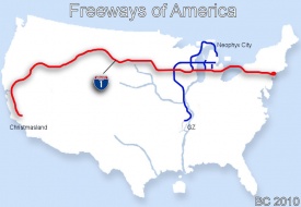
The Transamerica Freeway is a freeway built by Nyxboy crossing entirely the world America from the west coast at ChristmasLand all the way to the east coast passing through the northern regions of the world. The project has been planned and built with Nyxboy's company BC firm and is managed by the Amworld Transport Department located in Neophyx City at 124n 205e.
History
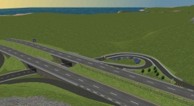
The idea of a transamerican freeway came out in early 2006 while Neophyx City was in its freeway Boom phase when time has come to find a way to prolonge the road from the Victoria Bridge in southern Neophyx. Not long after the Transamerica Freeway Project was proposed to the world caretakers, it was granted almost instantly and the construction quickly started in October 2006 where the current Transamerica would meet the Hamilton freeway. The freeway was officially completed in April 2009, 2.5 years after its groundbreaking. Nyxboy being busy during the peak of the NC6 era in Neophyx City and with the addition of the preparation of the world of Sedan resulted in many period of inactivity and is the main reason for why it took so long to achieve the project.
The Transamerica Freeway is since one of America's renowned landmarks.
The Victoria Expressway and the Transamerica Project I-190 Portion in Neophyx
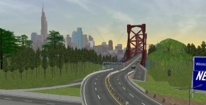
The Victoria bridge, then, already configured as a dual carriageway, inspired for a second east-west freeway that would serve the south of the city in parralel to the Hamilton freeway section (Now Liberty Freeway) serving the north of the city. However, the only potential path for a such project was already occupied by the Victoria Boulevard.
Since the Victoria Boulevard is the main arterial road crossing South Neophyx from the Victoria Bridge to end near the east shore, and because important landmarks such as the coliseum were located along its sides, it has been judged that withdrawing the boulevard would not be reasonable. This situation caused the idea to stay on paper for a few months.
The freeway has instead been first created and extended towards west with the new idea of creating a transamerican freeway from Neophyx, by the Victoria Bridge, to the West Coast of America where the world's most isolated built area, being Christmasland, is located.
It is a few months later that it has been finally decided that the famous Victoria Expressway would be built above the Victoria Boulevard to save the current state of the neighborhood. The Transamerica Project faced modifications so it would also been extended all the way to the east coast. The Erie bridge has been built to create the new link to the city from the east and is now the longest onwater bridge in the world of America.
The Victoria Expressway section of the Transamerica freeway crossing the city of Neophyx was originally numbered as Interstate 190, the rest of the Transamerica being identified as Interstate 90 until 2010.
2010 Renumbering
In june 2010, as part of the NC9 Plan, the Transamerica has been renumbered to become the Interstate 1 on all its lenght. The new identification became effective on June 11th 2010.
2013
Since January 23rd of 2013, based on a second revision to the NC9 renumbering, the Transamerica is identified as the Interstate 2.
Characteristics and Builds composing the Transamerica
Bridges
The Transamerica Freeway crosses on its way a total of five bridges
- The lost falls twin bridges
- Concrete bridge near the Valley Rest area
- Small Canyon Suspension Bridge near Incline Village
- The Victoria Bridge in Neophyx City
- The Erie Bridge in Neophyx City
Exits and access
- Christmas Land
- Valley Rest Area
- New exit(access going west only)
- Incline Village
- Liberty Freeway - Interstate 1 Junction
- Neophyx Freeway - Interstate 201
- West Neophyx
- Expressway 3
- Victoria Blvd/Expwy 5/Neophyx's Int'l Airport
- Eastern Neophyx
- Jeckill Hotel Resort
- East Vista Loop
Western Valleys Rest Area Accomodation Complex
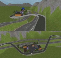
As the area from Christmas Land to Incline Village is relatively desert, a rest area has been built to make the area a little more interresting to drive throught. A close valley surrounded by high mountains has been picked to built accomodation buildings. Modern ramp have been built to access the complex. The rest area is composed of an information office, an America Police office, a gaz station with a conveniance store and restrooms. Also, falls have been added at the west end of the valley.
Picture Gallery
Photos depicting the Transamerica Freeway from the west to the east.
-
Transamerica passing through the rockies
-
Transamerica Bridges in front of Falls
-
Bridge Near Incline Village
-
Transam through forest near Incline Village
-
Exit to Incline Village
-
Approaching junction between the Transamerica and the Liberty Freeway.
-
Transam - Entering Neophyx City, 2011
-
Transam through Neophyx City Southern Neighborhoods
-
Transam in Neophyx at Erie Bridge
-
Transam - Erie Bridge 2
-
Transam - Erie Bridge 3
-
Transam - Exit to Jeckill Hotel Resort near the east coast
See also
| Freeways of America | |||||||||||
|
|
• |
|
|
• |
|
• |
|
• |
|
• |
|
| Unbuilt or Defunct | |||||||||||
|
|
• |
|
|||||||||


